For over two decades, Google Earth has offered a trusted window into every corner of the world. That changed on July 30, 2026, when Google introduced its Nano Banana 2 image-generation technology to Google Earth, briefly giving users the ability to produce fake satellite imagery. With the six-word instruction, “type whatever you want to see,” the feature allowed users to select a real location, enter a prompt, and generate fabricated scenes over existing satellite imagery. Google positioned the tool as a creative and educational feature, offering users the ability to reimagine real-world spaces, such as visualizing what an empty lot might look like if developed. However, within hours of its release, testers demonstrated applications far beyond those Google intended, generating images depicting Russian tanks in Kyiv, nuclear facilities on Iranian territory, and a flood of the U.S. Capitol, among countless other examples. Less than 24 hours after its launch, Google withdrew the feature, stating that it would be rolled back while the company worked to implement “stronger guardrails.”
While doctored and AI-generated images are hardly a new phenomenon, what distinguishes this incident is the context in which fabrication became possible. By integrating the Nano Banana 2 technology into real satellite imagery, Google blurred the boundary between visual evidence historically used to verify real-world events and AI-generated content. This distinction is particularly significant for researchers and analysts who regularly rely on satellite imagery to investigate war crimes and mass atrocities. Unlike most AI-generated content encountered on traditional social media platforms, satellite imagery has historically been treated as a relatively objective record of what is happening on the ground. It functions as an independent point of reference against which other videos, photographs, and claims circulating online can be assessed. Relied upon since the Cold War, images captured by space-based systems have served as a means of verification for governments, the media and the public, allowing analysts to even challenge official narratives when they conflict with the observable evidence. The technical and institutional barriers surrounding the production of satellite imagery have made it comparatively difficult to fabricate, reinforcing its value as an independent source of verification. Thus, part of the significance of Google Earth’s Nano Banana technology lies in how dramatically it lowered those barriers: while removing a single building from Google Earth used to require a government request, generating an entirely fabricated aerial scene briefly required little more than a text prompt. In doing so, Google gave the ability to manipulate a traditionally difficult-to-alter form of evidence into the hands of just about any user.
The consequences of undermining the reliability of satellite imagery extend into national security, as modern defence strategies increasingly depend on it alongside geospatial intelligence to support operational success. While nations rely on space-based systems to support national security objectives, militaries specifically use satellite communications and imagery for reconnaissance and intelligence gathering. For security alliances such as NATO, intelligence, surveillance and reconnaissance capabilities are paramount, contributing to situational awareness across land, air, and sea as an independent source to assess developments and inform decision-making, particularly as critical events unfold. Satellite imagery’s ability to monitor vast areas of terrain aids in identifying infrastructure developments, troop movements, equipment deployments and environmental changes, all relevant to strategic planning. While NATO does not specifically rely on Google Earth for operational purposes, instead using satellite providers such as Planet, the incident nevertheless illustrates what is at stake when generative AI threatens confidence in a form of evidence upon which security institutions rely.
Against this backdrop, Google Earth’s brief AI integration demonstrated how generative technologies can dramatically lower the barriers to producing doctored satellite imagery, a capacity that could extend well beyond Google itself. As these technologies become more within reach to other companies and state actors, fake satellite imagery could be produced more cheaply, quickly, and easily. In the hands of adversarial actors, that accessibility could facilitate the production and circulation of politically charged fabricated imagery across a much wider range of disinformation campaigns, including false depictions of troop movements, infrastructure damage, military deployments, or the aftermath of an attack. Introduced into an already contested information environment, such imagery could lend visual credibility to broader disinformation narratives, to reinforce existing biases and deepen political or social divisions.
Conversely, as satellite imagery becomes easier to fabricate, the reference point itself becomes more contestable. Again, while Google’s rollback may have removed this particular feature for the time being, it does not prevent similar capabilities from being developed elsewhere. For newsrooms in particular, this adds another layer to the verification process. Beyond determining whether an image or video has been misrepresented or edited, journalists must increasingly consider whether the content depicts a real event at all. The stakes are high as visual evidence is often used to report state conduct, meaning uncertainty over a satellite image’s authenticity can make those actions easier to dispute. A state, for instance, could deny real visual evidence by claiming that it was AI-generated, or present fabricated imagery as genuine. As this uncertainty grows, the public inches closer toward a broader “crisis of knowing,” in which the boundaries between credible evidence and AI-generated content become increasingly difficult to discern.
These outcomes have particularly troubling consequences for satellite imagery because efforts to manipulate it for strategic purposes predate generative AI tools. Following Russia’s downing of Malaysia Airlines Flight MH17 in July 2014, Russia circulated doctored satellite imagery to support claims that Ukraine was responsible, despite broader international consensus that a Russian missile struck the aircraft. Investigators identified inconsistencies including incongruous cloud patterns and evidence that the released images had been photoshopped. Further, when Bellingcat’s investigative journalist team analyzed the Russian-released images and the surrounding soil structures against publicly available historical imagery from Google Earth, they found that Russia had attempted to present photographs taken in June as captured in July. The irony is difficult to overlook: Google Earth itself provided a reference point through which manipulated imagery could be challenged, while tools such as the Nano Banana 2 make the production of such material substantially easier to create. What previously required greater technical expertise and resources was accomplished through a text prompt of anyone’s desire, expanding who can produce such material and how readily it can be circulated.
For NATO and its allies, the implications of Google Earth’s short-lived feature are therefore twofold: fabricated satellite imagery becomes easier to produce and disseminate, while adversaries gain greater opportunity to challenge authentic visual evidence, potentially undermining the shared understanding of events upon which unity and coordinated action depend. These risks emerge at a time when increasingly realistic synthetic content is already complicating verification. In a digital environment where people struggle to distinguish between authentic and AI-generated content, preserving confidence in trusted sources of information remains a significant obstacle. Google Earth’s brief experiment ultimately demonstrates what is at stake when accessible generative technologies are introduced into platforms valued precisely for their credibility. Even if stronger guardrails are implemented, they may not eliminate the possibility of circumvention, nor prevent similar capabilities from emerging elsewhere. As the barriers to AI fabrication fall, preserving trust seems to increasingly require rethinking how we rely upon and verify sources once treated as credible.
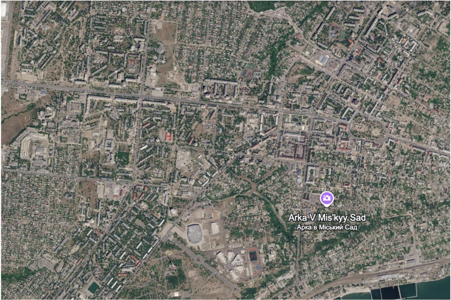
Image: “Google Earth Satellite Imagery of Mariupol, Ukraine (2026), by Dorigen Gray.
Disclaimer: Any views or opinions expressed in articles are solely those of the authors and do not necessarily represent the views of the NATO Association of Canada.